

FAÇK GOLD LICENSE 946 B2 (TASIAST AREA MAURITANIA)
The objective of this work is to argue the potentiality of the licence 946 B2.
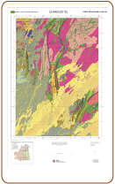
The said permitted is limited in west by the Mine of Tasiast with proved reserves that exceed 5 millions of gold metal ounces, on the other hand the 946 B2 is limited in to the southwest by the Tasiast–South licence (see the geological map of chami) with four anomalies that have been explored by geochemistry soil and test drillings types RAB.
These 4 anomalies named C613, C614, C615 and C616 (see the geology map of chami on Google earth) gave the gold results that vary from 2 ppb to 684 ppb (see the geochemical maps of the gold distribution by class of contents).
Our licence is also limited to the Southwest by the licence Khat attoui that is characterized by two anomalies named khat attoui and Nderek (see the chami geology map on Google earth « file kmz »).
This two anomalies were the object of works of geochemistry soil and test drilling, the gotten results show that the gold content varies from 2 to 48 ppb in khat attoui and from 2 to 157 ppb in Ndereck (to see geokhat and geonderek map respectively).